Posts

Showing posts with the label Boatspeed

New Maps in Boatspeed 1.13

Image
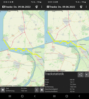
  New Maps We have some new maps with us, including satellite images and a mobile-optimized map. The feature is not final yet, some things can still change. Tracking Stats You may now drag the tracking - stats to a larger size. Thus it's easier to see your track's data.

Boatspeed 1.10 Comes With VMG - Display

Image
  VMG - VELOCITY MADE GOOD The new feature is the vmg, meaning the speed your boat makes against the wind. It is shown in the upper right corner of the sailing view, if you switch it on in the sailing config dialog. The vmg is given in the same unit as the speed, may km/h or knots or miles. A negative value indicates that you are sailing downwind. For the calculation of the vmg it is important to know the wind directions as exact as possible. That's why we implemented a new dialog to set the wind direction. To open this dialog long press at the vmg view or use the option menu entry. Here you have three ways to enter the wind direction: If you already know it for example from your weather app or another instrument just set it by the wheel and press ok. Use the build in compass. Adjust your device pointing to the wind direction and hold the "use compass" button so that the wheel will roll to the direction you point to. Use the wheather report which is provided by  Open Whea...

Boatspeed 1.8.7 released

Image
  Release 1.8.7 comes with to following new features: Navigation: 1. You can now enter a target locations coordinates, the position is added to the route. The following patterns are among the supportet formats: 54°22'12" N 007°12'13" E, 54°22'12"N 007°12'13"E, 54°22.12 N 007°12.13 E, 54-22N 007-12E, 54.1234 N 007.1234 E and more. 2. Switch the size of the nautical symbols of the map: Large symbols: Small symbols: The switch is located in the route settings: Sailing: Configure the frequency of speech output: Set the frequency for speed and heading announcements from "off" over 10s 30s 1m 2m 5m to every 15 minutes. Tracking: Now showing weekday-name in the track title. Fixes for Android 10 Tack - export fixed for android 10, you may now choose the  filename and directory. Anchor alert fixed for android 10. Due to system restrictions, the anchor alert view can't be shown automatically when an alert happens. Please press the anchor alert no...
Boatspeed 1.8.6

Image
This version comes with some new features: Navigation Edit View The edit - view has been completely refactored. The buttons are gone, you now use tap, long tap and double tap to create and edit routes: Create waypoints by tapping on the map. The app adds it to the route. If you tap next to the route a new waypoint is inserted between the waypoints next to it, otherwise appended to the end of the roude.  You move a waypoint by pointing at it and drag it to it's new location. The route is changed accordingly.  Delete a waypoint by tapping on it. Routes are saved automatically at your device.  GPX Import  Boatspeed now registers for handling gpx tacks and routes, and should be shown as an app for opening these files in the corresponding system-dialog.  The gpx-tracks and routes are shown in the navigation view. For performance reasons the mumber of waypoints to import is limited to 70.  Open to Google Maps If you have Google Maps installed on your device ...

Boatspeed 1.8.5

This is a bugfix release. I'm sorry there was an error in the code and it was not possible to buy the ad-free version which should be fixed now. 

Boatspeed 1.8.4

Image
Boatspeed 1.8.4  comes with a new tracking - handler that consumes less energy  and provides new modes:  Regatta - mode stores your position every 30 seconds, while the distance to the last position must be at least 10 meters. The location is not stored if the accuracy is not alt lease 10 m. By this a lot of data is produced and a lot of battery consumed, so this mode only fits for few hours. It uses the system-tracking handler as before. The ones with the new tracking handler are: Daysail stores your position every 2 minutes while the distance to the last position must be at least 20 meters, as well as the accuracy must be less than 20 m. This mode is suitable if you sail next to the coast and need detailed data. Cruising takes the data every 10 minutes if your position has changed for at least 20 meters. Use this mode if you want just an overview for your trip or if you are sailing far from the coast. Further on  speeded up the routes creation ...

Boatspeed 1.8.3

Image
Boatspeed 1.8.3 comes with new features: Achchor alert now shows the anchor area at the map and lets you see where your boat was swimming. You may also test the alert to be sure that it works even when your phone is gone down to sleep. It's now possible to see your distances and speed in miles and miles per hour beside kilometers, kilometer per hour, nautical miles and knots. There is a major bugfix with regatta countdown which now also works when the screen is locked. The screen lock is now automaticly handed over to the alter the countdown following regatta view. The map's open street map libraries were updated to osmdroid 6.1.4. And night mode is also a little smarter now. For more information pleas visit our wiki  and get the latest version at :

Boatspeed 1.8.2

Image
Boatspeed now features two edit modes in routing: WALK always add a new waypoint at the end of the route. SAIL lets you change or refine your route. The algorithm looks up for the closest existing waypoint and inserts the new waypoint there. Beside this here are some bugfixes: - Map-zoom fails when using the + - buttons. - Config dialog errors. - Boxhandler calculates wrong clipping for the route or track in western regions. - App crashes when font size is 0. For more information pleas visit our wiki  and get the latest version at :

Boatspeed 1.8.1

Image
Speech This is mainly a bugfix release for 1.8, but there is also a small new feature: For the regatta countdown and the sailing view you may enable speech output, meaning that you phone tells you when to start and what's your  current speed. Enable speech in the corresponding settings - dialogs of regatta - countdown and sailing. Bugfixes: - Help images not shown on some oder devices. - Program crashes sometimes when locking the screen. - Regatta timer not visible on landscape mode Please report bugs or feature proposals to  https://bitbucket.org/herberlin/boatspeed/issues?status=new&status=open Thanks for your help. Download boatspeed at:

Boatspeed 1.8

Image
We are happy to announce a new boatspeed release that comes with a lot of new features and improvements: The key feature of the 1.8.0 release is routing. You may now create and edit routes on the map and navigate along. Create Routes Create routes by tapping on the map (1). Delete waypoints by hitting the distance marker (2). To move a waypoint just delete it and create a new one at the right position. Routes are saved automatically at your device. You may want to rename your route (3) or invert (4) it when you go back. In the route-settings (5) you can adjust the line thickness and font size. Hit the go!-symbot (6) to start navigation. Hint: If the map is empty you can start your route from your current location by long tapping at the aim at the map. Route Navigation Four displays are available when navigating a route: (1) Your current heading (2) Your current speed (3) Heading to the next waypoint (blue background) (4) Total distance to last waypoint ...

Boatspeed Bug Tracking and Wiki

Boatspeed 1.8 comes with new html-help pages that also can be found online. Please visit  https://bitbucket.org/herberlin/boatspeed/wiki/help  and find the latest information on Boatspeed's features. You may also report bug - hopefully not too much -  or propose new features, so a bug reporting page for Boadspeed is now also there at:  https://bitbucket.org/herberlin/boatspeed/issues?status=new&status=open Thanks for your collaboration.

Boatspeed Release 1.7.4

Image
I published Boatspeed 1.7.4 with some bug fixes and enhancements.  The version is coming with a new database format which allows some new features. Database upgrade  Your track database is migrated automatically to the new format without any data loss. In the unlikely case of problems please let me know. With the new database, we now  track the boats heeling , which is also exported to csv and gpx data.  It is also shown at the maps marker bubbles, but only if you switch on the heeling view at sailing or navigation view. Ok, that's not very intuitive and I promise to refactor the UI in one of the coming releases. Thanks to the new database you can now undo some map waypoint editings . But if you delete the whole track this can't be undone. Cache location changed We are also moving the cache of the map tiles to a different location on the device. You can now delete the map-cache without deleting your track data at the same time. To do so use androids ...

Boatspeed price model

Staring today we introduce a new price model for our international customers. The price is no longer the same for all countries, but differs based on an index called purchasing power parity (ppp). That means a significant decrease for most of the countries, while in some western countries the price climbs to 3,- or more Euros. We regard this as a step towards greater price fairness and hope it faciliates customers to buy our product where it had been too expensive. Thanks for your understanding.

Boatspeed Tracking Refactored

Image
Boatspeed tracking now comes with OpenSeaMap  visualisation and a new fresh look. Among the new features there is also an export oft your tracks to jpeg image beside the already existings exports to pgx and csv. Download Boatspeed from GooglePlay

Boatspeed now features OpenSeaMap

Image
Boatspeed 1.6 new features OpenSeaMap nautical maps for navigation. Find the new release at Google Play Store:

BoatSpeed 1.4

Image
The new version of BoatSpeed comes with a new look and new features: - better background performance for tracking - overall stats for tracking days - anchor alert: Fix closed by operating system. - speed: heeling view - accuracy display - average speed values - new look Enjoy!

Boatspeed 1.3

Image
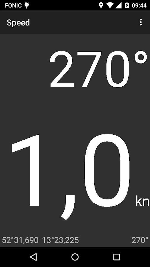
Boatspeed now provides tracking of your gps data including speed, heading and position. You may also export your tracks to gpx and csv. Boatspeed makes your mobile phone into an invaluable companion of when you're traveling with your boat. Speed displays the current speed, as provided by the GPS of your phone. To switch the display between km/h, m/s and kt press and hold the number showing the speed. A popup menu appears; you may also switch on the bearing field hiere. Below your current position and the direction is displayed. To share your position press and hold the display of the position. Tracking allows you to store the geocordes as well as the speed of your trip. "Tracking Start" starts tracking, which continues in the background, even if the app is no longer visible. There are two tracking modes, "regatta" provides more waypoints in regular intervals, "cruising" only stores heading and speed changes and saves battery live. The curr...

Boatspeed 1.2 released

Image
New features: Anchor Alert fix alert does not stop. Anchor Alert fix restart on rotate. Speed: Feature enable large display of bearing.

Boatspeed 1.1

Image
Boadspeed 1.1 released: New features: Ads now full screen once a day. New module regatta start countdown. Optimized font size of the main display. Landscape view of module speed.  Planned extension steps: Tracking, person-over-board, payed version

Boatspeed 1.0 Released

Image
herberlin.soft proudly presents: Boatspeed 1.0: Boatspeed makes your mobile phone into an invaluable companion of when you're traveling with your boat. Speed displays the current speed, as provided by the GPS of your phone. To switch the display between km/h, m/s and kt press and hold the number showing the speed. Anchor Alert reports by sound and light signal if your boat reaches a configurable distance from your anchor position.